
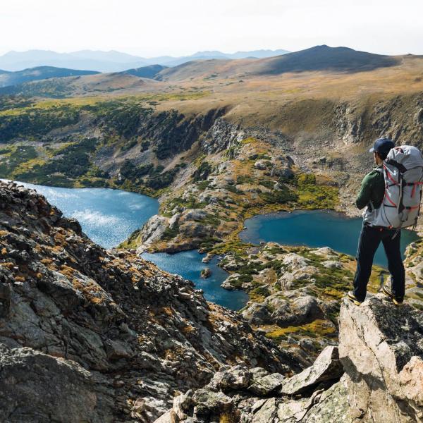
WALK OF THE MONTH - a hilltop view of Derwentwater
Written by George Fisher
Wednesday, 17 February, 2021

We’ve linked up with carfreewalks.org, the website for people who love walking but want to reduce their impact on the environment, to bring you this great walk.
#GETOUTSIDE WITH BRITAIN ON FOOT
Britain on Foot is an initiative with one clear objective; to encourage people to get active outdoors. It’s all about getting fitter, healthier and happier! This could mean walking to work, hillwalking, geocaching with the family, trail running or even mountaineering. Britain on Foot is now working closely with Ordnance Survey and is getting behind #GetOutside, the new high-profile campaign to inspire even more people to get active outdoors.
THIS MONTH’S WALK: A hilltop view of Derwent Water
Loop or linear? Loop
Map: OS Explorer: OL4 - The English Lakes: NW area
Total distance: 17.5 km (11 miles)
Total height gain: 610m (2,000ft)
Time: approx 6 hours 45mins
Start and finish: Grange
Unsuitable for: young children, prams and pushchairs, wheelchairs
Public transport: Borrowdale Rambler bus
1. Grange, OS Grid NY252174
Take the bus from Keswick down to Grange. You can also do this route from Keswick, but this option means you can finish at the tea shop in Grange.
2. Towards the water, OS Grid NY251182
About 0.8 km (0.48 miles) from 1
Follow the road north from Grange towards Derwent Water. Past the hotel, look for the footpath on your right.
3. Near the hotel, OS Grid NY262186
About 1.2 km (0.75 miles) from 2
Join the road along Borrowdale there is a verge to walk on and head towards the hotel.
4. Barrow Bay, OS Grid NY268203
About 1.8 km (1.1 miles) from 3
At Barrow Bay, take the hairpin turn back on the right, past the youth hostel.
5. Car park, OS Grid NY270196
About 0.7 km (0.44 miles) from 4
At the car park, take the footpath heading north that contours above Falcon Crag.
6. Walla Crag, OS Grid NY275210
About 1.46 km (0.9 miles) from 5
Continue via Walla Crag, with great views over Derwent Water.
7. Brockle Beck, OS Grid NY283220
About 1.3 km (0.8 miles) from 6
The path begins to wind into Keswick along Brockle Beck
8. Keswick , OS Grid NY267233
About 2 km (1.25 miles) from 7
Join the road and head into the town centre.
9. Cumbria Way, OS Grid NY261237
About 0.7 km (0.43 miles) from 8
Finished? Not a bit of it. Head past the bus station and over the bridge, taking an immediate left to join the Cumbria Way.
10. Portinscale, OS Grid NY252235
About 1km (0.63 miles) from 9
Pass through Portinscale, following the signs for the Cumbria Way.
11. Silver Hill Woods, OS Grid NY252222
About 1.24 km (0.77 miles) from 10
Through the woods south of Portinscale...
12. At the bottom, OS Grid NY247212
About 1.15 km (0.7 miles) from 11
...and here comes the added bonus of doing the loop from Grange. If you arrive at Catbells before midday, you will be climbing it with hundreds of others. Arrive a bit later, and you may get it to yourself
13. Cat Bells, OS Grid NY243197
About 1.54 km (0.96 miles) from 12
Continue to the summit of Cat Bells. On your own? Make the most of it...
14. Below Black Crag, OS Grid NY247189
About 0.9 km (0.56 miles) from 13
Descend via the steep-ish path that cuts under Black Crag.
15. Grange again, OS Grid NY250179
About 1.04 km (0.65 miles) from 14
This brings you out on the road leading in and out of Grange. There are some wonderful campsites around here, so worth stopping overnight if possible, then getting the bus to Keswick the next day.


Get 10% OFF Your First Order!
Sign up to our newsletter today and get 10% off your first order online (not available instore). Excludes Sale/Promotional items, Gift Vouchers, Watersports, Electronics, Arcteryx, Hilleberg, Dryrobe, Thule, Wahoo, Garmin & Norrona. Terms and conditions apply.
Use code 10OFF
Thanks for signing up! Enter code 10OFF to get your discount at checkout!